
Huge dinosaurs flee rising waters of Noah’s Flood in Australia
ABC’s Catalyst program reports Kimberley dinosaur footprints

In October 2012, Catalyst, the science television show of the Australian Broadcasting Corporation, featured amazing dinosaur footprints from the Kimberleys in north-west Australia.1

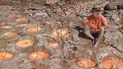
At James Price Point, 60 km north of Broome on the Dampier Peninsula, paleontologist Steve Salisbury was filmed checking multitudes of footprints preserved in the rocky platforms.
Catalyst reporter Mark Horstman says, “You’ve gotta be quick to study the fossils here. This tide is racing. And this was dry a few minutes ago. The tidal range is up to 10 metres, and the fossils are only visible at the lowest of low tides, so that’s for a few hours for a few days for a few months every year.”
Sand is washed in and out of the area, continually revealing new footprints. The program shows Steve Salisbury measuring a recently-exposed sauropod footprint about 1.7 metres long—a world record. He said the animal that made that print could be 7 or 8 metres high at the hip and more than 35 metres long.
These footprints were made during the global Flood of Noah’s day as recorded in the Bible.
There are so many clues in the rocks that point to the catastrophe of Noah’s Flood, yet Steve Salisbury and his team did not make the connection. They have been trained for years to think in one particular way, and Noah’s Flood is not on their radar. Worse still, if they ever did seriously float that possibility they would almost certainly lose their jobs (see Expelled).
Indeed, the footprints help us work out the timing of when the rocks were laid down during that year-long catastrophe.2 Clearly the land animals were alive when they made the prints, so the floodwaters had not yet peaked. After that, there would be no footprints because all land animals perished. Other evidence of the timing comes from the geology and from the landscape. This indicates it was not long before everything was inundated. The scale of this destruction is graphically described in the Bible:
“The waters prevailed above the mountains, covering them fifteen cubits [~7.5 metres] deep. And all flesh died that moved on the earth, birds, livestock, beasts, all swarming creatures that swarm on the earth, and all mankind. Everything on the dry land in whose nostrils was the breath of life died.” (Genesis 7:20–22)
One clue that we are looking at an unprecedented geological catastrophe is the enormous extent of the sedimentary deposits. Host Mark Horstman explains that the footprints are preserved in the Broome Sandstone, which extends for 200 km along the coastline and is up to 280 metres thick. He says, “At the time this was a vast river plain of muddy swamps and sandbars.” Actually, there was not a lot of mud.3 Mostly it was fine to very coarse sand with areas of gravel. The Broome Sandstone is known to cover the whole of the Dampier Peninsula.4 A river plain of such an enormous extent is monstrous compared with the rivers on the earth today. The Broome Sandstone points to an exceptionally large depositional system.
The surface of the sediment was soft and wet, and the animals walked on it soon after—before it had gone very firm. Steve Salisbury describes the tracks of a stegosaurus:
“It’s got four stubby little fingers on the hand and then quite a fat three-toed foot, and that combination is really characteristic of stegosaurs. … he’s gone for a bit of a slip down there. It looks like there’s a double step—he’s kind of slid for a bit and then had to gain his grip, and got to the bottom there and probably quite relieved that he’s made it … and then continued up that way.”
The idea of a river plain comes from the pattern of cross-bedding in the sandstone. These beds indicate that the water was flowing as the sediment was deposited. Some of the cross-beds are very large, so large that they indicate water flows of biblical proportions. In order to avoid such an interpretation, the sand deposits with the large cross-beds have been interpreted as forming in a desert. That’s right—a desert. This switch implies a puzzling sequence of environments. How could there have been a fast flowing river system, followed by a dry desert, followed by another river system? By ignoring the possibility of Noah’s Flood these palaeontologists create problems for themselves as they try to interpret what was going on.
As Steve Salisbury is filmed walking over the rocks we are told we are “exploring an extinct ecosystem as we walk through a landscape frozen in time.” However, what is preserved is quite unusual compared with ecosystems we see today. Fossils in the sandstone include marine organisms such as plankton and bivalves as well as land plants such a pine trees and ferns.4 Describing it as an ecosystem gives a misleading impression. So many different kinds of plants, animals and organisms that would be found in a normal ecosystem are missing from the deposits. That is because the dinosaurs, during the Flood, were not part of a normal ecosystem. The landscape was in the process of being destroyed by a devastation that impacted both the land and the ocean. This particular situation represented by the Broome Sandstone lasted for only a few weeks and months.
It’s interesting that Steve Salisbury recognises the transience of the situation. He says, “Most of the track sites that we see probably only represent, you know, between a few days and a couple of weeks, 130 million years ago, so they really do provide a fantastic snapshot.”
Note, “A few days and a couple of weeks”, and “snapshot”.
The footprints are the clear evidence for this brief, short time frame. They were made in soft sediment, and that provides a tight time constraint. And the imprints have been well preserved, which also constrains the time before the subsequent sediment was deposited on top. If the footprints had been exposed for any longer than a few weeks they would have been eroded away.
Clearly, people who talk about those mind-numbing time periods of 130-million years have a time problem: where do they propose to insert all those millions of years into the sediments?
Most people would imagine that the 130 million years was measured by precise laboratory equipment using hi-tech radioactive dating. That is not the case. The quoted date was decided by comparing the mix of fossils found in the sandstone with fossils found in other parts of the world.5 Actually, it is impossible to measure the ages of sedimentary rocks, or any other rocks, by analysing samples in the present (see The way it really is).
The Catalyst program captured the dramatic attempts of dinosaurs trying to escape the rising waters of Noah’s Flood some 4,500 years ago. Although the program made no reference to this global event, and presented the information exclusively in terms of evolution over millions of years, the evidence is plain to those who know what to look for. As my friend who brought this program to my attention said, “I have to admit I just thought of dinos running from flood waters when I saw it.”
References
- Kimberley Dinosaurs, http://www.abc.net.au/catalyst/stories/3603069.htm; 4 October 2012. Return to text.
- Walker, T., A biblical geologic model; in: Walsh, R.E. (Ed.), Proceedings of the Third International Conference on Creationism, Creation Science Fellowship, Pittsburgh, PA, pp. 581–592, 1994; http://www.biblicalgeology.net. Return to text.
- On the 1:250,000 geological map Pender the Broome Sandstone is described as fine to very coarse, mudstone in part, minor conglomerate, ripple marked, cross bedded, bioturbated in part, and plant fossils, SE 51–2, 1st edition, 1983. Return to text.
- Thulborn T., Impact of Sauropod Dinosaurs on Lagoonal Substrates in the Broome Sandstone (Lower Cretaceous), Western Australia, PLoS ONE 7(5): e36208. doi:10.1371/journal.pone.0036208, 2012. ): e36208. doi:10.1371/journal.pone.0036208; Thulborn interprets the environment as lagoonal which is contrary to the interpretation of a river plain Salisbury gives on the Catalyst program. One reason for the lagoonal interpretation is the huge geographical area of the sandstone. In other areas the sediments show cross bedding, which indicate flowing water. McCrea, R.T., Lockley, M.G., Haines, P.W. and Draper, N., Palaeontology Survey of the Broome Sandstone—Browse LNG Precinct, Department of State Development, Government of Western Australia, pp.12–13, 2011, report various interpretations by various authors at different outcrop locations. Return to text.
- Thulborn, ref. 4. McCrea, et al., ref. 4, report the age as Early Cretaceous (Valanginian to Barremian) based on limited biostratigraphic data (Nicoll et al. 2008). Return to text.


Readers’ comments
Comments are automatically closed 14 days after publication.