

Journal of Creation 28(1):68–76, April 2014
Browse our latest digital issue Subscribe
Has Mars undergone one or more RATE episodes?
A catastrophic and creation scenario is presented that effectively explains the present topography of the planet Mars. Mars is proposed as an analog of a typical US western desert—in the extreme. In these areas, heavy rain-filled monsoon seasons are followed by a dry climate where once-water-swollen rivers and lakes are dried up and parched. A history of volcanic eruptions is proposed which would have produced rain, flash floods, and volcanic flows that created a terraformed Mars complete with streams and lakes and a Martian ocean. Because of the low gravity of Mars, due to its mass, which is about 10% of the Earth’s, this ‘wet season’ is followed by evaporation and sublimation of water and other light gasses which largely escape the planet’s surface. This was initiated by a solar system-wide super RATE event—accelerated radioisotope decay—involving short, intermediate as well as long-half-life isotopes in the crust of the planet. It occurred during one or more RATE episodes—beginning possibly during Creation Week and ending during the Flood on the Earth, creating in-place hot spot volcanism which terraformed Mars. This has been termed the Mars-RATE Desert Hypothesis. These proposals are followed by geological evidence observed on the surface of Mars.

Water on Mars
Atmospheric pressure and temperatures would seem to eliminate the effects of water on Mars. The earliest Mars probes, for example Mariner 4, discovered that the atmospheric pressure was on the order of only 10 mbars, as compared to the Earth’s ~1 bar.2 This would seem to exclude any water-associated phenomena. But water-related atmospheric and ice phenomena are observed such as clouds, frosts, and polar caps as regular Martian features.
Of course, some of these phenomena arise from CO2 (dry ice). But many of the effects are undoubtedly water related. Likewise, the atmosphere has been found to be extremely cold and is not presently conducive to liquid water. Viking I measured temperatures ranging from 150–250 K. Viking I and II3 measured surface temperatures that seldom went above –10°C, usually staying in a band between –90° and –30°C. Phoenix4 shows a similar temperature range of –80° to –30°C). Very rarely did temperatures rise to above the freezing point of water. Nevertheless, liquid water phenomena are apparent.
 Figure 2. River in Yemen
The Mars Pathfinder noted rounded stones probably shaped by tumbling action of water in a stream or flood. Yellow areas on the surface were believed to be deposits left behind by evaporating water. Strata-bearing sedimentary rock from deposition of smaller fragments of rocks in water seemed to be apparent. The Phoenix Mars Mission (2007–2008),5 confirmed water ice on the surface of Mars. The Mars reconnaissance orbiter showed strong video evidence of liquid water flows in areas on warmer Martian slopes (actually in gullies) at low elevations.5 These areas experience higher atmospheric pressure where water might exist in a liquid form. The flows were thought to be due to melting ice from exposed permafrost (PF). Observed phenomena pointing to a once wet climate on Mars are plentiful. These include channels with dendritic drainage patterns like river beds on the Earth (see figure 1), alcoves, aprons, alluvial fans,6 mudflows, tear dropped ‘islands’ from water flows, etc. All of these phenomena are now in dry areas where the water had apparently evaporated or sublimated away. Some of these phenomena are shown in figures 1 to 9 below.

Volcanoes
Another phenomenon that has water-related associations is volcanism. The largest volcano shield region in the figure is Olympus Mons. It has a 600-km diameter base and rises to a height of 24 km above the Martian plains, with 6-km scarps encircling its base. Otherwise, it is a normal shield volcano caused by the alternating emission of fluid lavas and ash eruption episodes. The low-viscosity lava flows from shield volcanoes travel longer distances than those of other volcanic types, resulting in larger and thinner sheets of lava, often just 1 m thick with shallow slopes. Flows repeat over long periods of time, and the gradual buildup of hundreds of these flows slowly constructs the characteristically low, broad profile of a mature shield volcano. The Hawaiian chain of volcanos would have resulted in a smaller Olympus Mons type of volcano if it were not for plate tectonics to spread the eruptions over a great distance. This chain has a total volume of 750,000 km3 in its 43 volcanoes. The five volcanoes around the Tharsis ridge alone account for nearly 4.5 times this volume. The distribution of the larger volcanoes on Mars is shown in figure 10. The largest orange zone in the figure is Olympus Mons. Only 20 volcanoes have been named by the IAU on the surface of Mars. The five largest volcanoes on Mars are larger than their shield counterparts on Earth.

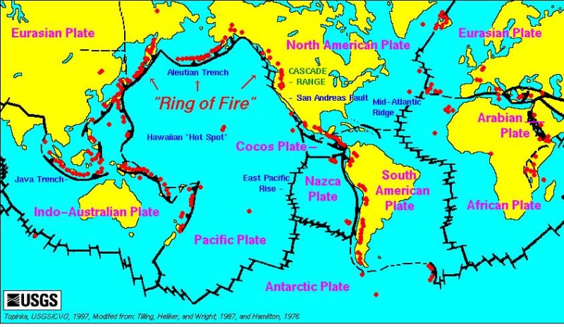
These include Arsia Mons, Alba Patera, Ascraeus Mons, Pavonus Mons and Olympus Mons. Volcanoes on Earth are scattered due to treadmill-like plate movements. Some 90% of all volcanoes lie within the ‘ring of fire’ along the edges of the Pacific Ocean and the tectonic plates (figure 11).
According to catastrophic plate tectonics theory,7 this was a result of recent events that happened from the outset of the Noahic Flood. On Mars, the apparent lack of multi-plate tectonics causes other effects than chains or rings of volcanoes. Hot spot volcanism accumulates lava emissions in one place instead of in chains. But both types of volcanism occur due to the same phenomena—radioisotope decay in the crust of the planet. This heats up the crust and produces high-pressure magma pockets, which leach upward, creating plumes at the surface.
The Mars-RATE Desert Hypothesis
NASA MOC

A catastrophic and creationary scenario that explains much of the present topography of the planet Mars is the Mars-RATE Desert Hypothesis. The means of this occurrence is accelerated radioisotope decay, which was the main emphasis of the RATE project.8 Western Deserts in the US, like those in Arizona and Mexico, have seasonal heavy rains and flooding followed by long periods of drought. Dried up streams and very reduced or dried up lakes are common sights to the traveler in our western states. In Arizona, this is also a seasonal occurrence. The summer monsoons mark the wet season. During this time, lakes are full and streams are swollen, and the possibility of flooding is likely. This is followed by a dry season for the rest of the year. The next year, the cycle repeats itself—dry, followed by wet, followed by dry, etc.
I propose that Mars is an analog of an extreme desert. I postulate that there is a history of volcanic eruptions producing rain, flash floods, and volcanic flows, which created a terraformed Mars complete with streams and lakes and an ocean. Because of the low gravity of Mars, due to its mass, which is about 10% of Earth’s, this ‘wet season’ is followed by evaporation and sublimation of water and other light gasses which largely escape the planet’s surface. The details of this process follow (see figure 12). Volcanoes put out CO2, H2O, N2, and SO2, which, together, create clouds, rainfall, streams, lakes, etc.—a terraformed Mars. Mars acts like the Earth for a brief time except that there is no carbon cycle since there is no life on the surface.

Rain takes CO2 and SO2 out of the atmosphere, which causes cooling and more precipitation. The rain continues to remove gasses, thinning the atmosphere and cooling it. Thus, much of the greenhouse gasses are removed. This cumulative action is called ‘the Runaway Ice-house Effect’.9 This drastically cools the atmosphere, and freezes out a layer of water-soaked soil that will ultimately become a PF layer.
Ultraviolet radiation now floods the atmosphere, breaking up the water molecules in the air. On the ground, H and O2 escape due to the low surface gravity and the thin atmosphere’s inability to absorb the UV. The remaining water soaks into the ground and joins the ground water. Much O2 combines with ‘irony’ surface soils to make the rusty-looking surface. Hence, we see a red Mars today with the unaided eye or our backyard telescopes.

Next, the ground water freezes and PF forms. Some CO2 is photo-dissociated, but some of the unaltered CO2 is heavy enough to be retained. The atmosphere thins out and loses its light gasses, leaving a thin CO2 atmosphere.

The runaway ice effect not only freezes much of the water into PF, but also into the northern and southern polar caps. After this, the topography is that seen in the present day—a dry Mars. This dry season is characterized by long periods of drought. During dry times, asteroids are free to strike the surface, since there is little atmosphere to act as a shield. Because of the PF, when the ground is heated by meteor and asteroid collisions, it produces mud flows about the crater fields as we see in. There is little erosion to conceal the crater blemishes. Craters scatter dusty regolith about the cratered terrain.
Carbonate rocks are known to be rare on the surface of Mars. This is a problem for those believing that Mars has a watery past as proposed here. I believe that carbonate rocks do form during the wet phase but they do not have time for recycling and volcanic venting. The meteors that strike the surface bury the landscape in the regolith, including the carbonate rocks. Thus, over time, the regolith/volcanic debris and carbonate-bearing sediments should alternate.10 The presently exposed sediment is mostly regolithic metamorphic/igneous rocks. After this cold dry season, the volcanoes eventually erupt again.

This causes the same cycle to recur—dry followed by wet, followed by dry, etc.
Instead of being a year apart, as these ‘seasons’ are in Arizona, on Mars the wet seasons are centuries apart. I believe Martian volcanoes are poised for another eruption, and a wet season will follow. When will Mars be terraformed again? Perhaps there was an ocean originally. And perhaps the strength of the cycle is weakening with each repetition. These are speculations which I will explore further.
The remaining water is in the polar caps, insulated by dry ice, and in the crust hidden as PF. When the PF is exposed (for example, by asteroid strikes, volcanism, earthquakes) at the lowest altitudes (highest pressure), and heated (as radiant heat from sun or radioisotope decay), it again flows for a brief time before it sublimates, creating additional mud flows and gullies from buried layers of PF melts. In addition, ice-laden glacial-type flows12 should follow as the climate cools. Images of valley glaciers13 have been detected by the Mars Orbiter. Vast concealed glaciers exist on the surface of the red planet that have the same appearance as glaciers outside of Anchorage, Alaska, today (see figure 13).
A National Geographic report stated that the Tharsis Range volcanoes may not be extinct and that:
“If sufficiently large eruptions do eventually occur, they could spew enough heat-trapping carbon dioxide and water into the atmosphere to warm the red planet up from its current cold, dry state—at least for a little while.”14
Thus, some secular scientists are now agreeing with the thesis of this paper (which I have been thinking about for some 10 years or more), that these fantastic volcanoes which would cover an area the size of the west coast of the US (see figure 14) may re-erupt, terraforming Mars for a short time.

Sky and Telescope magazine15 admits to the same scenario, “volcanic eruptions pumped tremendous quantities of gasses into the atmosphere … water started to precipitate … perhaps (to) form an ocean”.
The runaway ice effect not only freezes much of the water into PF, but also into the northern and southern polar caps. After this, the topography is what we see today—a dry Mars. This dry season is characterized by long periods of drought. During dry times, asteroids are free to strike the surface, since there is little atmosphere to act as a shield. Because of the PF, when the ground is heated by meteor and asteroid collisions, it produces mud flows about the crater fields, as we see in figure 5. There is little erosion to conceal the crater blemishes. Craters scatter dusty regolith about the cratered terrain.
The RATE connection
I propose that the accelerated radioisotope decay occurred during the RATE episodes, perhaps during the Flood on Earth on Creation Week, resulting in hot spot volcanism on Mars without plate tectonics, catastrophic or otherwise. This created the massive, oversized volcanic mountains visible on Mars today. Such vast eruptions extended over large portions of the Martian surface, resulting in a fantastic emission of water vapour and other greenhouse gasses into the atmosphere. This ultimately terraformed Mars as proposed in previous sections. The sudden heating of the crust due to accelerated decay would produce vast areas of heated subsurface magmas that would result in surface volcanism. Volcanic emissions are some 90% water vapour and are followed by torrential rains on the Earth. This would be followed by subsidence and eventual loss of most of the atmosphere as outlined above, thus producing the present desert topography of Mars in a brief time, fitting the creationary 6,000-year age frame. The clues of a watery past are easily discernible on the surface of Mars as noted in the earlier section. These events likely occurred several times in the past from either multiple RATE episodes or from the latent heat from a single, but long-lasting accelerated radioisotope event, followed by additional and weaker eruptions of the present day. Slower emissions would also produce future eruptions as they do presently on the Earth. In that case, these events would subside in strength, becoming weaker and farther and fewer between as the energy from previous accelerated decay episodes (or from a single eruption) are lost.

The original terraforming episode was initiated at the outset of the RATE event on the Earth. Probably this initial super event was so violent that it could have produced an ocean on the surface of Mars, perhaps causing the present-day lowlands in the northern hemisphere and the apparent shore lines of Syrtis Major, Arabia Terra, and Chyse Planitia (see figure 15).
By setting the average altitude as ‘sea level’, the northern lowlands, which are very smooth with fewer craters, are at a depth of 4 km, and the volcanic mountains (Mons) rise to a height of 4 km above a plain with an elevation of about 2 km. There is a large inland dry lake bed about the size of a lunar mare and a great lake called Hellas Planitia, as well as the bays along the ‘sea shore’. All of these could have been formed by the original terraforming event. I note that this ocean portion of the globe is especially free of craters, much the same as the mare on the Moon. If the terraforming event happened during Creation Week and persisted for a while as a shallow ocean until the next event, it would have been an effective ‘meteor shield’, especially during the deep-water times combined with an atmosphere which would have been likely early on. We note that there are craters, some fairly sizable, but they are few and far between. Perhaps this is a hint of a heavy bombardments that occurred, which pummelled our solar system’s terrestrial bodies with craters. Earth is more complex with its catastrophic plate tectonics, and much more work is needed to explain its topography. But it is possible that many seas of today’s Earth came from one or multiple RATE events.

Evidence for alternating sedimentary layering on Mars
One of the confirming evidences for multiple events would be the presence of alternating sedimentary layering on Mars. Indeed, there is sedimentary layering on Mars! But these phenomena could be caused by alternating directions of wind-blown dunes, which are also prevalent on Mars, or something as simple as lake deposits. But I am talking about thick layering, and thick layering has also been found on Mars! Some of the thickest layers have been found in West Candor Chasma and were discovered by HiRISE.16
This article states:

“The layers may have been deposited from windblown materials, fall of volcanic sediments, or carried in by water, or all of the above. Subsequently the layers may have been altered by groundwater, producing hydrated minerals such as sulfates. The enhanced colors in the sub image are related to the minerals or to overlying dust or sand. The dark blue sharp-crested ridges are sand dunes.” (see figure 16).
Another image taken by HiRISE is figure 17. These layers occur in an unnamed crater. In the related article, we read:
“Sequences of cyclic sedimentary rock layers exposed in an unnamed crater (located at 8N, 353E) in Arabia Terra, Mars. NASA/JPL/Univ. of Arizona Researchers at the California Institute of Technology (Caltech) and their colleagues have found evidence of ancient climate change on Mars caused by regular variation in the planet’s tilt, or obliquity. On Earth, similar ‘astronomical forcing’ of climate drives ice-age cycles.”18
I certainly do not espouse ancient and long-age ice-age cycles, but the actual cause of the cataclysmic geology could very well be the Mars-RATE Desert Hypothesis.

Figure 18 shows a drawing of a possible method of formation for the exposed layered terrain previously shown (MGS MOC Release No. MOC2-265O, 4 December 2000). This was done for the Mars Global Surveyor Mars Orbiter Camera as “Sketches Illustrating Proposed Formation of Layered Units, Massive Units, and Thin Mesa Units in Martian Terrain.” The layers could have been built from debris from crater impacts (regolith) and any other precipitating phenomena like water, volcanic ash or lava, thus creating layers of different materials and colour. Erosion could be caused by much of the same phenomena, such as micrometeor impacts or massive solar storms (a naked Mars does not shield its surface from either).
Figure 19 shows complex layering in West Candor Chasm, an auxiliary canyon off Valles Marineris. The statement that accompanies the image is very telling and fits into our ideas here:
“Various explanations are put forth as to their nature: Are they marine sedimentary, lake beds, volcanic flows, volcanic ash deposits, or other unknown types, or as seems likely a combination of these modes of layering?”19


Ten major repeated periodic patterns of 10 minor layers was discovered with the HiRISE camera of the Mars Reconnaissance Orbiter (MRO) in the Becquerel crater (20) and is believed to be evidence for varying but periodic changes in the inclination of Mars over the past 12 billion years. “Each layer has weathered into a stair step in the topography where material that’s more resistant to erosion lies on top of material that’s less resistant to erosion.”20 This is the first discovery of spatial periodicity in rock layers on Mars, indicating a complex repeating pattern of erosion and deposition.
A referee asked me to make some sort of prediction from our study. Just for speculation, if we apply a catastrophic scenario to this phenomenon, then the 10 major layers could have happened over the past 6,000 years, making a 600-year periodicity. Since the telescope is about 400 years old and no bright spots on Mars were recorded by Galileo, I would expect another start to a major cycle (of volcanic eruptions) in less than 200 years in about ad 2200! However, this is sheer speculation at this point!


Finally (the images are nearly endless), I show features on the exposed permafrost layers, which are due to a crater (figure 21), that show repeated layers that may be proof for the conjecture of the Mars-RATE Desert Hypothesis. Perhaps the ridges shown are PF layers from repeated terraforming events. This will have to await further surface exploration to add credibility to my claims. Regardless, the existence of large-scale layering of the crust of Mars cannot be argued.
Martian dry river beds (arroyos) show evidence of periodic flooding
In his paper, Geological Observations of Martian Arroyos,21 Hartmann states:
“… major arroyos with tributaries and the network of fine equatorial channels imply a more widespread source of fluid. Some channels probably had episodic activity. Time intervals between episodes are uncertain, but marginal cratering evidence suggests that the episodes may have been more than 107 years apart [emphasis added].”

He calls these events Martian fluvial episodes. Fluvial episodes could be caused by repeated volcanic eruptions that result in a planet-wide, or region-wide, terraforming and flooding rather than other oscillation-like high-amplitude changes in the inclination and displacement and the accompanying spreading/melting of polar ice as suggested by others (one mentioned in this article). In passing, I note here that Mars does not have a large moon to gyrostabilize the planet, like Earth, so that gyrations of the angle of inclination of Mars could well be happening, and should be an object of future creation research and geophysical computer modelling.

But whatever the cause of these topographic oscillations, the RATE connection must be apparent on Mars if the RATE episodes actually happened, and if they occurred on Mars as well as on Earth. I think this is likely, since I believe the Creator would have us explore its effects on the simpler geologic strata of Mars, unhindered by plate tectonics. I believe He has done this with a different phenomenon that is very apparent on our present-day moon and the origin of its mare, unhindered by the effects of water and other sources of erosion, as well as the absence of plate tectonics.22 Psalm 33:14 says: “From the place of His habitation he looketh upon all the inhabitants of the earth.”
And in Psalm 66:4: “All the earth shall worship Thee, and shall sing unto Thee; they shall sing to Thy name. Selah.”
Further work
The proposals contained in this paper are broad and very involved and represent a mere proposal at this point. They should be followed up, if possible, by computational modelling and a thorough analysis of the topography of Mars.
References and notes
- Astronomy Program. Bob Jones University. Return to text.
- The Mariner Mars Missions, nssdc.gsfc.nasa.gov, accessed 18 August 2013. Return to text.
- Viking Mission to Mars, nssdc.gsfc.nasa.gov, accessed 18 August 2013. Return to text.
- Weather report for Mars Sol 1, 27 May 2008, nasa.gov, accessed 18 August 2013. Return to text.
- NASA Spacecraft Data Suggest Water Flowing on Mars, nasa.gov, accessed 18 August 2013. Return to text.
- Moore, J.M., Large alluvial fans on Mars, J. Geophysical Research 110(E04005):1–24, 2005. Return to text.
- Baumgardner, J., Catastrophic Plate Tectonics: The Physics Behind the Genesis Flood; in: Ivey Jr, R.L. (Ed.), Proceedings of the Fifth International Conference on Creationism, Pittsburgh, PA, pp. 113–126, 2003. Return to text.
- Vardiman, L., Snelling, A.A. and Chaffin, E.F. (Eds.), Radioisotopes and the age of the earth: Results of a young earth creationist research initiative, Institute for Creation Research, El Cajon, CA, and Creation Research Society, Chino Valley, AZ, 2005. Return to text.
- Freedman, R.A., Geller, R.M., Kaufmann III, W.J., Universe, 9th edn, W.H.Freeman and Co., New York, p. 285, 2011. Return to text.
- Recently the Spirit rover did uncover some carbonates on the surface of Mars, The Martian Chronicles, martianchronicles.wordpress.com, accessed 18 August 2013. Return to text.
- isset.org, accessed 18 August 2013. Return to text.
- Forget, F., Haberle, R.M., Montmessin, F., Levrard, B. and Head, J.W., Formation of glaciers on Mars by atmospheric precipitation at high obliquity, Science 311(5759):368–371, 2006. Return to text.
- Sample, I., Mars orbiter detects vast concealed glaciers on the surface of red planet, The Guardian, 21 November 2008, guardian.co.uk, accessed 18 August 2013. Return to text.
- Minard, A., Mars Volcanoes May Re-Erupt, Hawaii Comparison Shows, 18 October 2007, news.nationalgeographic.com, accessed 18 August 2013. Return to text.
- Smith, D.E., Zuber, M.T., Solomon, S.C. et al., The global topography of Mars and implications for surface evolution, Science 284(5419):1495–1503, 1999 | doi:10.1126/science.284.5419.1495. Return to text.
- Sedimentary Layers in West Candor Chasma, 27 April 2012, redorbit.com, accessed 18 August 2013. Return to text.
- Impact Crater with Peak, Mars Odyssey: THEMIS, themis.asu.edu, accessed 18 August 2013. Return to text.
- Researchers find ancient climate cycles recorded in Mars rocks, phys.org, accessed 18 August 2013. Return to text.
- Short, N.M., Stratigraphic units maps of Mars, Geology of Mars; The Martian Atmosphere; Ice at the Poles, fas.org, accessed 18 August 2013. Return to text.
- Mars Climate-Change Cycles in 3-D, The Daily Galaxy, dailygalaxy.com, accessed 18 August 2013.Hartmann, W.K., Geological observations of Martian arroyos, J. Geophysical Research 79(26):3951–3957, 1974. Return to text.
- Hartmann, W.K., Geological observations of Martian arroyos, J. Geophysical Research 79(26):3951–3957, 1974. Return to text.
- Samec, R.G., On the origin of lunar maria, J. Creation 22(3):101–108, 2008. Return to text.


Readers’ comments
Comments are automatically closed 14 days after publication.